When discussing The Zone, those of us who live here effortlessly refer to a property’s relation to the nearest town. For visitors and prospective buyers of property in The Zone, they are ofttimes left wondering just where the heck we are actually talking about. This article will help to familiarize the reader with the lay of the land here in The Zone and to understand the different “flavors” that the various areas of The Zone offer.
Due to their very nature, coastal tourism zones around the earth are linear. They run along the coast in what is frequently a string of towns and areas. So what are we talking about when we say “The Zone” in Costa Rica’s southern Pacific region? Caveat: The Zone is being marketed internationally as “Costa Ballena” (Whale Coast). “The Zone” and “Costa Ballena” are synonymous terms.
Costa Rica’s southern Pacific zone is made up of 3 towns. North to south: Dominical, Uvita and Ojochal. The boundaries defining The Zone are not hard edged and differ depending on who you talk with. The Zone extends north of Dominical to a blurry area up around Quepos/Manuel Antonio and south to Palmar Norte. Included in this soft edge are other small and much lesser known towns such as: Hatillo, Matapalo, and Portalon to the north. To the south there are: Coronado, Cortes and San Buenaventura (San Buenas). These are not comprehensive lists, but instead represent the construct here. The three primary towns of Dominical, Uvita and Ojochal
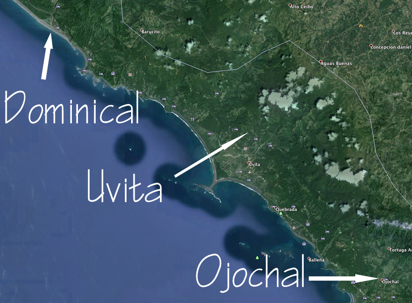
are normally used as a point of reference from which we can orient a property’s location.
Note: when you are here and driving around The Zone, note that there are 3 (an only 3) gas stations just to the north of each of the towns. So, when you are heading south on the coastal highway, and you see a gas station, you are getting close to a town.
In addition to towns, there are numerous “areas” in The Zone such as Escaleras, Lagunas, Ballena, Dominicalito, San Buenaventura, Punta Mala, etc… but that gets so fine grained as to exceed the purpose of this article. As you grow in familiarity with The Zone, these areas will grow in relevance.
The topography of The Zone is unique in Costa Rica. The mountains, for the most part, come down to the Pacific ocean, resulting in the opportunity to live at altitude right near to the ocean. However, due to its relatively recent geological formation, The Zone’s topography is anything but uniform. By sheer chance, the coastal mountain range runs parallel to the ocean between Dominical and Uvita. At Uvita, it (the coastal mountain range) turns inland a bit and then returns to the coast, forming the area that is facilitating the formation of Uvita as the commercial and social center for The Zone.
From this point towards the south, the topography is quite erratic and so consequently one never knows, until they actually step foot onto a property, just what its characteristics will be. In the area between Uvita and Ojochal there are some of the best view properties in the area, but not necessarily. This is where us real estate guys help in knowing your criteria and viewing the properties that are appropriate to your search.
OK, them’s the broad strokes. We’ll pull out the smaller brushes in the next article.
Keep in mind that you are getting my read and interpretation of things here. Included in this orientation series, I’ll also offer some of my educated “guesses” as to what the future holds for the various areas. Stay tuned for the next article that deals with these aspects of The Zone.